Climate experts: El Niño won’t affect Island weather this summer, but a warmer winter is coming
The impact of the incoming El Niño won't be apparent on the BC Coast until the end of the year.
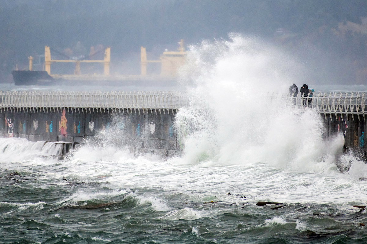
The El Niño may lead to higher sea levels and stronger storm surges in the winter for BC. Photo: James MacDonald / Capital Daily
There’s been a sense of panic in the media over the last couple of weeks, with predictions of a “super El Niño” set to hit the globe with devastating results. While an El Niño is certainly likely to arrive soon—on Tuesday, the United Nations (UN) put out a warning urging the world to prepare for it—concerns of it being super may be premature.
The UN’s World Meteorological Organization (WMO) says the term is not an official classification—El Niños can be weak, moderate, strong, or very strong (very strong being considered super)—but even at a moderate level, this naturally occurring climate pattern can contribute to more severe weather events.
El Niño is a phase of a cyclical climate pattern known as the El Niño-Southern Oscillation (ENSO). It causes warmer ocean temperatures in the tropical Pacific, which can alter weather patterns globally. La Niña is the cold phase, creating opposite concerns. These phases cycle every two to seven years.
While some scientists are warning it could be one of the strongest El Niños in decades, others say it’s too soon to make that call. Right now, Victoria climate experts aren’t too worried.
Charles Curry, a UVic researcher and regional climate impacts lead at the Pacific Climate Impacts Consortium, says there’s an 80% chance that an El Niño will occur soon, but only a 30% chance that it will be strong.
“The latest information I've been able to find doesn't quite track with some of the media,” Curry told Capital Daily. “As of now, there's nothing to indicate it's going to be very remarkable in that sense.”
Stay connected to your city with the Capital Daily newsletter.
By filling out the form above, you agree to receive emails from Capital Daily. You can unsubscribe at any time.
Curry says the impacts of this El Niño will become clearer as we head into the fall and winter. He says if it’s strong, BC can expect a warmer, drier winter.
We’ll be the first to notice the effects in Canada, says Bill Merryfield, climate researcher with Environment Canada and UVic.
“Vancouver, BC, and Vancouver Island are actually, in particular, on the front lines of the impacts of El Niño on Canada,” Merryfield said. “These will be seen, particularly if there's a very strong El Niño, first in the coastal oceans, which will start to warm up during the fall and into the winter and perhaps spring months by up to a couple of degrees.”
“This can have interesting impacts on marine life. For example, fish species that would normally be found further south may be found in BC waters during that period.”
Merryfield says coastal flooding may also be a concern when the winter storm season hits.
“[El Niño] can raise winter sea levels on the coast by up to several centimetres, and so that may slightly worsen the types of flooding you get when you have extreme high tides and also storm surges,” Merryfield said.
These effects will likely kick off near the end of December, he said.
A warm, dry winter brings with it another concern—it doesn’t bode well for the Island’s future snowpack levels, according to both Curry and Merryfield. This year’s levels have been concerningly low, and a second balmy winter isn’t going to help improve them.
Snowpacks are essential for sustaining river and stream flows in the summer and reducing the risk of droughts and wildfires.
“Last time I checked, [snowpacks were] about 11% of normal on the Island here, which is really unprecedented at the moment,” Curry said. “That's a buildup of the weather we've been experiencing for the past few winters.”
The current lack of snow is unrelated to El Niño—rather, climate change is to blame. The combination of the two could mean El Niños will bring even hotter temperatures in the future.
“I think the long-term warming of the climate certainly is factored into that,” Merryfield said. “Canada, as a whole, is warming twice as rapidly as the planet on average—and maybe about three times as rapidly when you get into the northern regions—so that long-term warming trend certainly will make having a lower snowpack than we're used to on the West Coast a more common thing going into the future
“El Niño just kind of accelerates that tendency in years when it occurs.”
Stay connected to your city with the Capital Daily newsletter.
By filling out the form above, you agree to receive emails from Capital Daily. You can unsubscribe at any time.

.jpeg)
.jpg)